


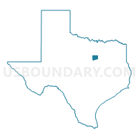
Johnson County PUMA, Texas
About
Outline

Summary
| Unique Area Identifier | 194103 |
| Name | Johnson County PUMA |
| State | Texas |
| Area (square miles) | 734.46 |
| Land Area (square miles) | 724.69 |
| Water Area (square miles) | 9.77 |
| % of Land Area | 98.67 |
| % of Water Area | 1.33 |
| Latitude of the Internal Point | 32.37951120 |
| Longtitude of the Internal Point | -97.36482340 |
Maps

Graphs
Select a template below for downloading or customizing gragh for Johnson County PUMA, Texas


Neighbors
Neighoring Public Use Microdata Area (by Name) Neighboring Public Use Microdata Area on the Map
- Ellis County PUMA, TX
- Heart of Texas COG (Outside McLennan County) & Navarro County PUMA, TX
- North Central Texas COG (West)--Hood, Erath, Palo Pinto & Somervell Counties PUMA, TX
- Parker County PUMA, TX
- Tarrant County (South Central)--Fort Worth City (Southeast)--South of I-20 PUMA, TX
- Tarrant County (Southeast)--Mansfield (North) & Arlington (Southwest) Cities PUMA, TX
- Tarrant County (Southwest)--Fort Worth (Southwest) & Benbrook Cities PUMA, TX
Top 10 Neighboring County (by Population) Neighboring County on the Map
- Tarrant County, TX (1,809,034)
- Johnson County, TX (150,934)
- Ellis County, TX (149,610)
- Parker County, TX (116,927)
- Hood County, TX (51,182)
- Hill County, TX (35,089)
- Bosque County, TX (18,212)
- Somervell County, TX (8,490)
Top 10 Neighboring County Subdivision (by Population) Neighboring County Subdivision on the Map
- Fort Worth CCD, Tarrant County, TX (791,745)
- Arlington CCD, Tarrant County, TX (491,713)
- Burleson-Joshua CCD, Johnson County, TX (53,895)
- Cleburne CCD, Johnson County, TX (45,619)
- Granbury East CCD, Hood County, TX (41,920)
- Alvarado CCD, Johnson County, TX (40,488)
- Weatherford Southeast CCD, Parker County, TX (27,636)
- Midlothian CCD, Ellis County, TX (21,246)
- Glen Rose CCD, Somervell County, TX (8,490)
- Grandview CCD, Johnson County, TX (6,897)
Top 10 Neighboring Place (by Population) Neighboring Place on the Map
- Fort Worth city, TX (741,206)
- Mansfield city, TX (56,368)
- Burleson city, TX (36,690)
- Cleburne city, TX (29,337)
- Crowley city, TX (12,838)
- Rendon CDP, TX (12,552)
- Keene city, TX (6,106)
- Joshua city, TX (5,910)
- Pecan Plantation CDP, TX (5,294)
- Alvarado city, TX (3,785)
Top 10 Neighboring Unified School District (by Population) Neighboring Unified School District on the Map
- Mansfield Independent School District, TX (138,558)
- Crowley Independent School District, TX (86,222)
- Burleson Independent School District, TX (52,131)
- Granbury Independent School District, TX (47,990)
- Cleburne Independent School District, TX (37,778)
- Midlothian Independent School District, TX (32,577)
- Joshua Independent School District, TX (23,803)
- Alvarado Independent School District, TX (17,611)
- Venus Independent School District, TX (9,565)
- Glen Rose Independent School District, TX (8,417)
Top 10 Neighboring State Legislative District Lower Chamber (by Population) Neighboring State Legislative District Lower Chamber on the Map
- State House District 96, TX (231,782)
- State House District 10, TX (184,699)
- State House District 93, TX (179,024)
- State House District 61, TX (176,054)
- State House District 58, TX (169,146)
- State House District 97, TX (168,045)
- State House District 59, TX (149,195)
- State House District 60, TX (148,990)
Top 10 Neighboring State Legislative District Upper Chamber (by Population) Neighboring State Legislative District Upper Chamber on the Map
- State Senate District 10, TX (834,265)
- State Senate District 30, TX (823,594)
- State Senate District 22, TX (789,412)
Top 10 Neighboring 111th Congressional District (by Population) Neighboring 111th Congressional District on the Map
- Congressional District 12, TX (831,100)
- Congressional District 6, TX (809,095)
- Congressional District 17, TX (760,042)
Top 10 Neighboring Census Tract (by Population) Neighboring Census Tract on the Map
- Census Tract 1302.04, Johnson County, TX (9,890)
- Census Tract 1113.01, Tarrant County, TX (9,405)
- Census Tract 1110.16, Tarrant County, TX (9,243)
- Census Tract 1304.07, Johnson County, TX (7,992)
- Census Tract 1407.04, Parker County, TX (7,495)
- Census Tract 1304.08, Johnson County, TX (7,296)
- Census Tract 1110.08, Tarrant County, TX (7,216)
- Census Tract 1602.09, Hood County, TX (7,206)
- Census Tract 1304.10, Johnson County, TX (6,927)
- Census Tract 1305, Johnson County, TX (6,897)
Top 10 Neighboring 5-Digit ZIP Code Tabulation Area (by Population) Neighboring 5-Digit ZIP Code Tabulation Area on the Map
- 76063, TX (61,361)
- 76028, TX (59,744)
- 76065, TX (28,986)
- 76049, TX (25,130)
- 76033, TX (24,819)
- 76036, TX (22,352)
- 76009, TX (19,759)
- 76126, TX (19,395)
- 76031, TX (17,759)
- 76058, TX (17,123)